Tlalpan
Tlalpan is a borough (demarcación territorial) in Mexico City. It is the largest borough, with over eighty percent under conservation as forest and other ecologically sensitive area. The rest, almost all of it on the northern edge, has been urban since the mid-20th century. When it was created in 1928, it was named after the most important settlement of the area, Tlalpan, which is referred to as “Tlalpan center” (Tlalpan centro) to distinguish it from the borough.
This center, despite being in the urbanized zone, still retains much of its provincial atmosphere with colonial era mansions and cobblestone streets. Much of the borough's importance stems from its forested conservation areas, as it functions to provide oxygen to the Valley of Mexico and serves for aquifer recharge. Seventy percent of Mexico City's water comes from wells in this borough.
However, the area is under pressure as its mountainous isolated location has attracted illegal loggers, drug traffickers, and kidnappers; the most serious problem is illegal building of homes and communities on conservation land, mostly by very poor people. , the government recognizes the existence of 191 of the settlements, which cause severe ecological damage with the disappearance of trees, advance of urban sprawl, and in some areas, the digging of septic pits. The borough is home to one of the oldest Mesoamerican sites in the valley, Cuicuilco, as well as several major parks and ecological reserves. It is also home to a number of semi-independent “pueblos” that have limited self-rule rights under a legal provision known as “usos y costumbres” (lit. uses and customs).
What is now called “Tlalpan center” or sometimes “the historic center of Tlalpan” began as a pre-Hispanic village located at the intersection of a number of roads that connected Tenochtitlan (Mexico City) with points south. This village was renamed Villa de San Agustín de las Cuevas in 1645, with the last part “de las Cuevas” referring to the many small caves in the area. During the colonial period, the village was a modest farming village, known for its fruit orchards. However, the forests of the area made it attractive to the elite of Mexico City who built country homes and haciendas here, much as they did in other areas south of the city such as Chimalistac, San Ángel and Coyoacán.
Many of these homes and manor houses of the former haciendas still remain in and round Tlalpan center. As the urban sprawl of Mexico City only began to reach this area starting in the mid-twentieth century, much of the former village has retained its provincial streets, older homes and other buildings with façades of reds, whites, blues and other colors, although a number have been converted into other uses such as cafes, restaurants and museums. This makes the area similar to neighboring Coyoacán, and like this neighbor, Tlalpan center is popular with visitors, especially on weekends as people come to see its provincial main square/garden, mansions, narrow winding cobblestone streets lined with large trees, eat in its restaurants and cafes and visit its many nearby parks and other green areas. One popular area with cafes and restaurants is La Portada, on one side of the main plaza.
Tlalpan center has eighty structures from the 16th to the 20th centuries that have been classified by INAH as having historic value. Some of these include old Tlalpan Hacienda, the former home of the Marquis de Vivanco and the San Agustin parish church. The borough of Tlalpan has sought World Heritage Site status for the area because of these structures, the area's history and the nearby site of Cuicuilco.
The center of this former village is the main square or garden officially called the “Plaza de la Constitución” but better known as the “Jardín Principal” (Main Garden). Visually, what stands out is the large kiosk in the center, but historically more important is the “Arbol de los colgaldos” (Tree of the Hanged). This tree, still alive, was used to hang political enemies and bandits, including those opposed to the invading French Army during the French Intervention in Mexico. On weekends, vendors set up stalls selling handcrafts and other items. To one side of the plaza, there is a cantina called La Jalisciense, one of the oldest in Mexico City, having been in operation for over 135 years. Facing the Jardín Principal, there is the “Palacio de Gobierno” (Government Palace), which was the site of the government of the State of Mexico, when Tlalpan served as state capital for six years in the early 19th century. Since then, it was used as a barracks for Benito Juárez’s soldiers, a jail, a residence for the Empress Carlota and the site of the Instituto Literario (today the Universidad Autónoma del Estado de México). Today, it serves as the headquarters of the borough, although it is also commonly referred to as the “ex palacio municipal” (former municipal palace) referring to the time when Tlalpan was an independent municipality in the State of Mexico. The current structure was built between 1989 and 1900 in Neoclassical style.
On another side of the main square, there is the San Agustin Church. The village church was established here in 1547 by the Dominicans, but the current structure on the site dates from the 18th century. It has an austere façade and faces the main square. Around it is an atrium, some simple gardens and a patios shaded by fruit trees. A fire at the end of the 19th century destroyed the Baroque altar, replaced with the sober one seen today. This parish is the site of the annual San Agustin de las Cuevas Festival, which is the largest religious event in the borough. Casa Frissac is located just off the main square. It was built in the 19th century in French style as the residence of Jesús Pliego Frissac. According to local legend, bandit Chucho el Roto lived here at one time. In the 20th century, it belonged to Adolfo López Mateos then it became the site of the Lancaster School, which closed in the 1980s. In the 1950s, it was used as a set for the film Los Olvidados, by Luis Buñuel. Today, the house is still the protagonist for a number of local ghost stories; however, its official function is that of a cultural center called the Instituto Javier Barros Sierra. This center began operations in 2001 after 21,800,000 pesos worth of remodeling, which restored the structure to much of its 19th-century look. The center has hosted art exhibits by photographers, graffiti artists, and more—many with a political message. While the center's authorities insist the center is non-political, members of Mexico's PAN party raised objections to the content in the center's first year.
The Museo de Historia de Tlalpan (Museum of the History of Tlalpan, is housed in a building known as “La Casona” (The Mansion), which dates to 1874. In addition to its age, one of its claims to fame is that it is the site of the first long distance telephone call in Mexico, calling a telephone in the then-separate Mexico City. This call was made on 20 March 1878 and the telephone used to make the call is on display here. The mansion was classified as a historic monument by 1986, and it was converted into the current museum in 2003 after extensive remodeling, which included restoration of the original murals. The museum explores the culture and history of the Tlalpan borough. It also has a permanent collection of art work by Gilberto Aceves Navarro, Alberto Castro Leñero, Isabel Leñero, Javier Anzure Joëlle Rapp and Jorge Hernandez.
The museum was opened to be part of a “cultural circuit” integrated with other facilities such as Casa Frissac. Prior to the opening of this museum, the only other museum (as opposed to a cultural center focused on classes) was the Museo Soumaya, which is private. Much of the museum's collection of historic items was donated by over one hundred individual residents and include documents, photographs, artworks and more. These donations cover the eight rural “pueblos” in the Ajusco area, traditional barrios and the major apartment complexes in Coapa and San Lorenzo Huipulco as well as Tlalpan center. An organization called the Centro de Documentacion Historica de la Delegacion now accepts, organizes and cares for the borough collection of historic items.
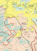
Map - Tlalpan
Map


Country - Mexico


Currency / Language
| ISO | Currency | Symbol | Significant figures |
|---|---|---|---|
| MXV | Mexican Unidad de Inversion | 2 | |
| MXN | Mexican peso | $ | 2 |
| ISO | Language |
|---|---|
| ES | Spanish language |